Showing posts with label Black Creek. Show all posts

14 December, 2021

Paddling in Black Creek/Lagoon

I really want to call it "Black Lagoon" instead of Black Creek; it sounds so much more exciting, bringing to mind images from the horror movie "The Creature from The Black Lagoon".  So henceforth I shall call it Black Lagoon!  It really is more of a lagoon than a creek anyway, since it is entirely sea water diluted somewhat intermittently by runoff from the surrounding swamp.  We even tested the salinity after a series of heavy rainfalls where 2 small streams feed into the lagoon and found that it was in sea water range.  We were hoping to have a source of fresh(ish) water for watering our vegetable garden during the dry season, but it is far too salty for that!

The fuchsia route into Black Lagoon.

I launched the kayak from the same spot as before, but this time I headed south, towards Little Monkey Cay.  I looped around the cay, which is a roost and/or breeding site for lots of sea and wading birds - brown pelicans, white ibises, cormorants, anhingas, green herons, white egrets, little blue herons, and great blue herons.  I learned recently that another name for Little Monkey Cay is Crown Cay.  Next time I am out there, I will try to get some good  bird photos.  I didn't get any this time because the light was against me.  

I turned into the entry to Black Lagoon and began a very leisurely paddle towards its north end.  
The narrow entry is just to the right of center.

Right at the mouth, I saw a great blue heron fishing from the prop root of a mangrove tree.  It flew off as I paddled closer.
Great Blue Heron,
The banks of the lagoon are lined with a mix of red, white, black, and button mangroves, with the red being predominant and right along the edge.
The lagoon widens just after the mouth.  The water is the color and clarity of black coffee due to the tannins leached out of the dead leaves in the swamp.

Flocks of immature little blue herons with their tie-dyed transitional mix of white and blue feathers scattered before me as I headed north.  A lovely green heron sat immobile as I went by, but it was too far away for my camera phone to do it justice.  The same with the immature white ibises.

Two small streams feed into the north end of the lagoon.  I paddled up each stream as far as I could.  The vegetation changes a little bit and the large white mangroves were more evident.

I love this white mangrove tree with its network of fat branches and massive prop roots  Each time I see it I want to climb it.  So far I haven't . . . .

Younger white mangroves with a tangle of prop roots hide lots of birds.

Perhaps you can spot the immature white ibis with its long, orange, decurved bill and lots of dark feathers remaining in its plumage at the center of the photo.  Also what I think is a snowy egret in the upper left quadrant. Or it could be a very juvenile little blue heron that still has all its white feathers.

As I made my way to our back landing where I ended this trip, I heard a squirrel cuckoo, lots of brown jays, kiskadees, and unidentifed birds and saw a bare-throated tiger heron.  I recently installed an app on my phone that identifies birds by sound (the Merlin App).  Next time I will be sure to have it running while I am out in Black Lagoon.

In all it was a 2.7mile trip and took about 2.5 hours because I kept a leisurely pace with lots of stops to appreciate the beauty.  Forgot to mention the trip to Great Monkey Cay and back was 2.9 miles. 


30 September, 2016

Falling On My Head Like A New Emotion

We could see it coming ...
6:30am - here comes the rain again.
6:54am - falling on my head like a memory.
7:00am - falling on my head like a new emotion.
7:00am - Rain over Black Creek to our west.
Blue-grey tanager getting wet in the tamarind tree.
7:06 - sun shining down on the eastern horizon.
7:27am - rainbow beyond Black Creek.
7:28am - A flock of white ibises flies across the rainbow.
Tamarind flowers in the rain.
Young pods mixed in with the flowers.
The flowers are orchid-like in appearance, but they are legumes related to peas and beans - as you might guess based on the seedpods.
The series of photos above was taken in the space of an hour during which a quarter of an inch of rain fell.  The day is now bright, sunny, and fresh with a light breeze.


06 April, 2015

Run Through the Jungle

Back in my pre-retirement life, I was gym rat.  I loved to go to the gym and was there at least 5 days a week.  I found that a good, sweaty workout was a great stress reliever.  Fortunately the very job that generated this stress also provided access to a wonderful gym on site.  I miss that gym - much more more than I miss my career!

Here in Englishtown, there is no gym, so I am learning to make do with what is available.  With our neighbors at SteppingStones (a former fishing resort) and Barebones Tours, we have developed some paths and trails through the jungle that connect our properties.
Our cabana is at the bottom of the photo where the red line starts.  My mini warm-up, the red line, consists of walking down our stairs and then ~200 ft to the start of the orange line.  I start my run at the orange line, take the left turn to Black Creek and back and then the run up and down the stem of the Y 2 or 3 times to get 3 miles in before coming back the way I came for my cool-down.  That is Great Monkey Caye at the righthand edge of this Google Earth image.  BareBones Tours is at the north end of the orange line.  This whole stretch is the Englishtown of the title of this blog and is labeled as such on the official government land plats.
Click the link to listen to CCR while I take you on my 
The beginning of the orange line.  That is my little bird-watching seat at the bottom right.  This trail goes through swamp, so the path had to be built up from sand and seagrass brought in one wheelbarrow load at time over a period of 5 or so years.  Washed up logs and wood scraps from building projects help to stabilize the path.
In the rainy season, there is standing water on both sides of the path.  Even during the dry season, the ground is squishy. 
You can just make out the footbridge just before the path bends to the right.  A series of 4 bridges lets the water drain from the right toward Black Creek to the left.  This swamp is a haven for agoutis, gibnuts, raccoons, all kinds of birds, snakes, lizards, crabs, insects. Huge ferns, 3 mangrove species, and other water tolerant plants are a nearly impenetrable (to humans!) barrier on either side of the trail.
The branch of the Y that goes to Black Creek has been in place longer than the other branch.  It goes through palmetto and reed beds.
Here it looks like a path through a dry woodland, and while it is a little higher and dryer than other parts, it is still wet on either side.
The branches of the Y converge at SteppingStones Resort and the stem of the Y basically follows the shore up to BareBones Tours.  This section is on dry ground, all it took was clearing a path and light maintenance to keep it cleared.
Sea to the right and jungle to the left.
Sea view with lilies, palms, and sea grapes.
Some times I have company on my walks and runs.  This is Kalli from SteppingStones.
A great path with a sea breeze to help dry the sweat.
Jungle to the west.
There may have been a dwelling in this little clearing at some time in the past.
The lot to the left has been cleared recently.  The owners live in the US and may build a vacation cabana here.  Or may not; plans in Belize tend to stay fluid.
This is a great old tree.
BareBones is on the other side of the palm.  Our friend Craig Pearlman, owner of BareBones, lives there.
View across the water toward the east just.  That is Great Monkey Caye at the left.
View to the south back toward our place.  This is low tide; you can see some green seagrass exposed in the shallow water.  The little island is Little Monkey Caye.
More views through the seaside jungle.
Headed back south, the sea is to the left and jungle to the right.
It takes a little fancy footwork to run the path, ducking for leaning trees (that dark line on the leaning tree is a termite tunnel), stepping over tree roots, avoiding crab and armadillo holes.
This leaning palm and the tree in the previous photo were very likely blown over in Hurricane Iris in 2001.
Dennis accompanied me on this walk to help clear away some of the vines and branches in the path. This area is the site of former Bob's Paradise, a resort that was blown away in Hurricane Iris.  Major hurricanes are quite rare here in southern Belize.  Iris was the unusual one with a zigzag course that delivered her to this protected pocket in full strength without loosing any force by passing over Honduras or Nicaragua on the way.
Back on the branch of the Y between SteppingStones and our place with a good view of one of the footbridges.
This area was a tangled mess of downed trees and vines.  We cleared away only what it took to make the path.
Finally, there is my birdwatching seat again on the left; the end of the trail is just ahead.
There is always something noteworthy to see along the trail.  Appropriately enough, on Easter Sunday I saw 2 bunny "rabbits" on the trail.  "Rabbit" is the local name for agouti.  They did look a lot like bunny rabbits, albeit bunny rabbits with very short ears, as they bounded into the swamp.  Just like me, they "... run through the jungle.  Whoa, don't look back to see."

07 November, 2013

Wanted: Lotus Esprit Amphibious Vehicle

I mentioned in my last post that the Monkey River Road was flooded.  Monkey River Village itself was flooded, too. Here is a satellite view of Monkey River Village, the end ofMonkey River Road, Black Creek, and Englishtown (where we live) just north of  the mouth of Black Creek, with Black Creek proper to our west.  
The sinuous Monkey River winds along south of the Monkey River Road.  At the mouth of Monkey River, the dirt road ends in a parking lot with a small dock.  On the south side of the mouth is Monkey River Village.  A handful of dwellings are on the north side of the river.  a little farther north is Black Creek .  Our place (red asterisk) is at the south of the area called Englishtown, and Craig's place (orange asterisk) is at the north end.  
The village has no paved roads or sidewalks (the road ends on the north side of the river and the village is on the south side), but does have houses laid out in lots along "streets" and paths across public areas.  
There are close to 40 households in the village along with at least 1 bar, 1 church, 1 school, 2 guest house/hotels, and several places you can buy a hot lunch.
Even lower than our place, the village is only a few feet above sea level and is also bordered on 2 sides by the river.  With as much rain as we had in just a few short days, it is easy to see how the village gets waterlogged.  Richard took the next 2 photos with his phone October 28th. 


Ironically, with the road flooded, the village ran out of "pipe water" (Belizean for municipally supplied water).  How did that happen?  It was only about 6 or7 years ago that the government provided funds for the village to install its own well, water pump, water tower, pipes, and water meters to the inhabitants of Monkey River Village.  The well and pumphouse are about 3 miles from the village on the site of a natural fresh water spring; otherwise, a well around here will hit a water table that is brackish rather than fresh.  The water tower is a little removed from the well and pump.  Prior to this setup, villagers relied on rainwater just like we currently do.  The pump is turned on and off manually, which means that someone has to go to the pump house to turn it on and then go back to turn it off once the water tower starts to overflow - a very low tech system.  The village has an official Waterboard who oversee the operation, meter reading, and bill collection. But with the road flooded, no one could get to the pumphouse to turn the pump on.  The solution to this problem?  Go by boat!
Take the boat up the Monkey River (which, remember, is in flood!) to the farm at the bend in the road.  Drive the boat up the boat launch and down the driveway to get to the road.  Then drive the boat down the road to the pumphouse!
The next 2 photos were also taken by Richard on the boat trip to the pumphouse.
Crossing the flooded farm by boat. 
Going down the road in the boat.
 They were successful in getting the pump on and water to the village.  You do what you gotta do, eh?

Meanwhile, back in Englishtown, we had a little flooding from Black Creek at the rear of our property, but it receded quickly.
Black Creek water edging onto our property from the west.
 And from the east, we were getting pounded by the sea.
The waves were so high, they were breaking over our dock.
The rough sea brought a lot of things to the beach.
This sea heart was deposited right at my feet by a wave.


Cubic yard after cubic yard of dead sea grass was washed ashore, along with plastic trash of all descriptions and some little treasures.
The lovely sea purse was mixed in with dead sea grass and a plastic bottle cap. 
We always have the sea grass raked up to use as a soil amendment.  Basically our "soil" is just sand, so organic material is a great addition.
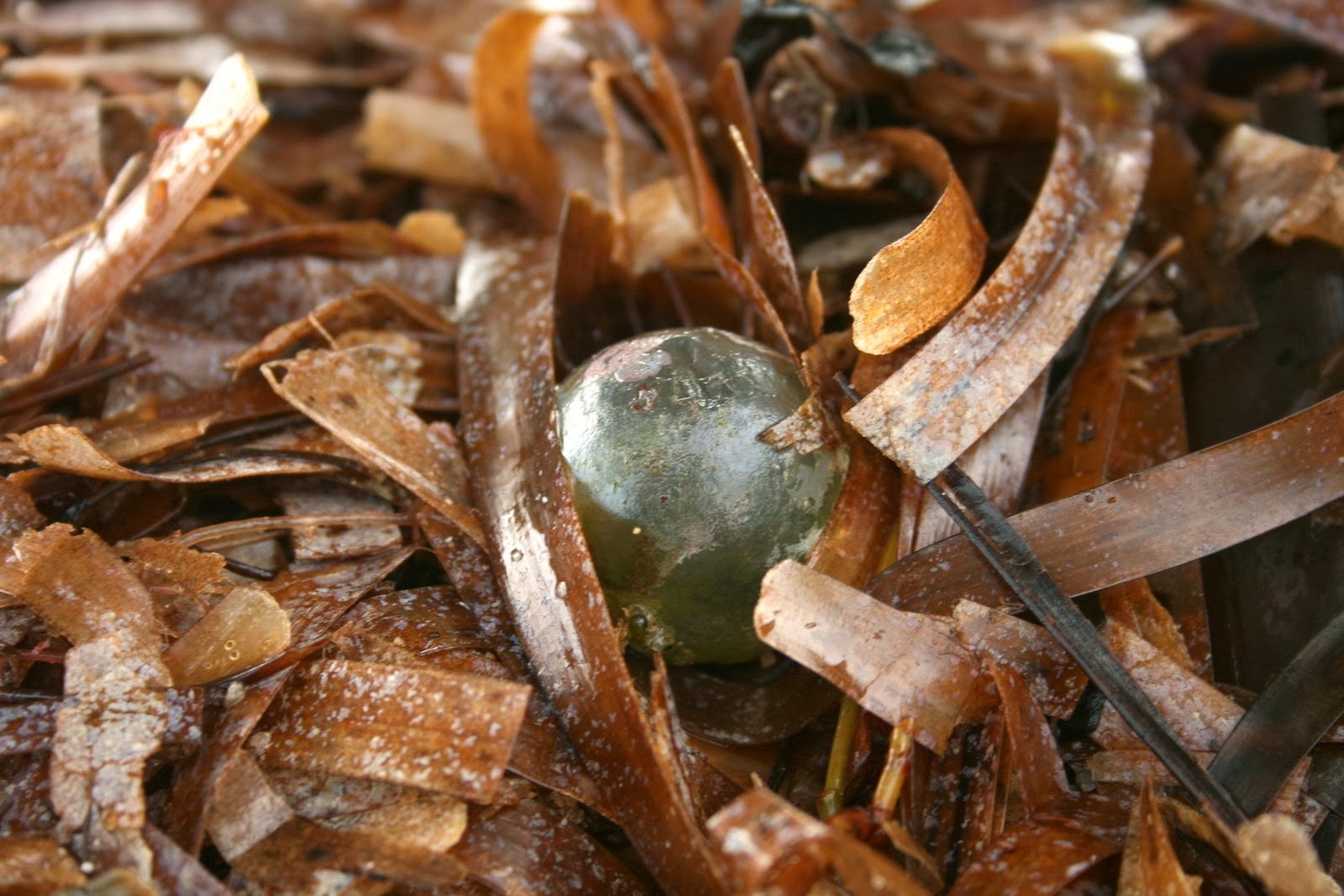
The occasional golfball-sized Valonia ventricosa was in the sea grass too.
 I loved spotting Valonia ventricosa.  Valonia, also called sailor's eyeball, is a green alga that is normally attached to something hard like coral or rocks throughout tropical waters.  The stormy waters must have detatched quite a few of them.  They are very cool organisms.  Each ball is just a single cell covered with a cell wall that looks like glass!  I got a little carried away trying to take photographs that do them justice.
With a little help from Picasa photo editing, I tried to highlight the metallic sheen of the Valonia.
This single celled green alga is home to other organisms that grow on its surface.
After more than a week of stormy, rain-filled nights, we finally got some clear and calm weather.
I love the sea when it is calm and flat.  I can spend hours mesmerized by subtle greens and silver colors.
 After several days of clear calm weather, the roads and villages dried out.  And that means - 
The guys unloading our lumber.  This is boat-load 1 of 3.
 You got it - we can get our next construction materials delivered.  Work will soon re-commence on the cabana.

If anyone has a lead on James' Lotus (seen in "The Spy Who Loved Me") for a good price, don't hesitate to let me know!  I have some sea hearts and sailor's eyeballs I could trade ...

Posted by Picasa